maps

The Brazilian Drug Trade in Maps

Map by Addicted04 at http://commons.wikimedia.org/wiki/File:BRA_orthographic.svg

I am currently working on a research project comparing the drug trade in Mexico with its counterpart in Brazil. I have an outstanding undergraduate student, Tony Zamoro, working on this project with me. It has been a great deal more difficult to find information on Brazil’s drug trade than Mexico’s, but he has managed to locate a wide range of maps -from Insight Crime, Newsweek and other sources- that display the drug trade and cartels visually. Here are some links to these maps.

Homicides in Brazil

Mexican Prisoners in Latin American Countries

Drug Routes in the Amazon

Favela Pacification in Rio de Janeiro

Areas of PCC Influence

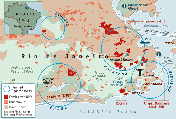
Olympic Zones and favelas in Rio de Janeiro

What I find most interesting about the maps is that they often focus on favelas, rather than individual states. Of course, the PCC has influence throughout most of Brazil. The Mexican drug cartels also often overlap. For example, the situation in the state of Guerrero is complex, while even in Sinaloa -the home of the Sinaloan cartel- the drug cartels still compete. There are also areas in Mexico -such as Juarez- where competing cartels seem to have fought each other to a state of exhaustion, as the falling death rate in this city suggests. My point here is that there are similarities between the nature of drug cartels in the two countries. Still, the Brazilian drug trade is much more defined by the control of small urban environments, rather than broad swathes of territory, as is the case with Mexico. My question is: how has the differing character of the two countries’ borders shaped the geography of the drug trade and the character of the drug cartels?

The Brazilian drug trade is also driven by the diverse mix of drugs used within Brazilian urban areas, unlike in Mexico where rates of drug use have been lower than in the United States. In 2005 I interviewed drug traffickers and users in Sao Paulo, Brazil. The drug market there was stratified by age. Older users were more likely to inject drugs, including cocaine, whereas younger users more commonly used crack. It was also the case that people often varied the drugs that they used, even within a single day. The Mexican drug cartels also have diversified, but the Mexican drug market internally is perhaps not as large or as complex as Brazil’s.

If you are interested in Latin America, you might wish to read either my book on the region’s AIDS epidemic, or my study of military terror in Brazil.

Shawn Smallman, Portland State University

Map of Mexican Drug Cartels

I’m currently working on a project that compares the drug trade in Mexico and Brazil. My goal is to try to understand the factors that have made the Mexican trade so bloody in comparison with Brazil’s trade. I believe that part of the reason is the nature of border. Most of the cocaine trafficked into Brazil passes through highly porous borders in Amazonia, which would be impossible to close to the same degree as the U.S.-Mexican border. The Brazilian drug trade is also geographically fractured, despite the existence of major drug organizations such as the First Capital Command (PCC), Red Command, Pure Third Command, and “Amigos dos Amigos.” The Mexican drug trade also overlays a major movement of migrants from southern Mexico and Central America to the United States; this both creates a population vulnerable to crime, but also develops networks that move people from south to north outside the control of the state. There is no parallel migration in Brazil. One issue I face with this project is the large number of variables that make the drug trade different in these nations. …

Map of other countries overlaid upon the United States

World map from CIA factbook, 2004

I love maps and use them in my “Introduction to International Studies” class frequently. I also use the maps from the textbook in a series of classroom exercises, to encourage students to think critically about how maps portray data, such as different visions of security. So I was delighted to come across this webpage, which is intended to put the United States into perspective. The webpage provides nineteen maps of states or nations overlaying the United States. My favorite map is actually the first one. It’s hard to understand the size of Alaska until you see a map of the state superimposed over the mainland, with the Aleutian islands reaching into northern California, while southeastern Alaska touches northern Florida. The map of Brazil -which reaches from central Saskatchewan to southern Mexico- also conveys the immensity of that nation. I won’t describe the other maps, except to say that Chile’s size would allow it to reach from New York to Bogota, while Africa’s immensity becomes clear. In the spring I’m teaching a fully online “Introduction to International Studies” course, and I think that I’ll need to create a class activity around this site.

Shawn Smallman, Portland State University

Maps and Politics

I’m teaching an “Introduction to International Studies” course this quarter, and I began by talking about colonialism

"World Map On Brick Wall" by Ohmega1982
“World Map On Brick Wall” by Ohmega1982

and its legacy. As part of this discussion, I talked about the psychological and educational legacies of the imperial period, including how it has shaped our modern world view. I then showed the class three different maps: a Mercator map, a Hobo-Dyer projection, and a map that had south at the top. After class a student shared a link with me, which showed an episode of West Wing, and a map of Africa with the U.S., India and China (amongst others) within it. Here was exactly the exercise I had done with the students, only with much more humor. Thanks to my student Colleen for sharing this, and Rollie Williams for his post, “We have been misled by an erroneous map of the world for 500 years.” Want to see even more maps? Look here.


Shawn Smallman, Portland State University

Maps for an International or Global Studies Class

I love maps, as I’ve talked about before in this blog. So I was enthralled by a recent article tiled “40 more maps that explain the world” in the Washington Post. This collection of maps cover diverse topics, that range from the historical (shipping routes during the colonial period) to the contemporary (a map of income inequality globally). I could imagine using the majority of the maps over the course of my “Introduction to International Studies” class. For example, in my section of postcolonialism, I could use the maps of the Spanish and Portuguese empires, African empires before the European invasions, the “What Africa might have looked like had it never been colonized” map as well as the “1916 European Treaty to carve up the Middle East.”  In my section on economic globalization, I could use the map that shows the commodity chains for Nutella, as well as “Nobel Laureates since 1901, by region.” I also emphasize demographics in my introductory class, so the map on where populations are growing and shrinking globally would be a useful one. It clearly shows the challenges that Germany, Eastern Europe and Russia face. In the week on security, I would certainly use the maps showing “walls,” the Arctic land grab, the territories of Mexican drug cartels, terrorist attacks worldwide as of 2012, naval firepower in the Pacific, as well as territorial claims in the South China sea. There are even a couple of great maps for a new section that I am developing on indigenous peoples. Lastly, the map “World War Two in Europe: Day by Day” is simply an amazing achievement in historical geography. In short, the article is well worth investigating as a possible resource for an introductory class, as well as just to admire some beautiful maps.

Prof. Smallman, Portland State University

Realism and Human Security: A Map of U.S. Security Interests

Last week in my class we focused on security issues, and I compared and contrasted two powerful approaches in the field: Realism and Human Security. Realism is an older approach to security, which claims to have historical roots that stretch back to Thucydides, but perhaps truly began with E.H. Carr in the 1930s. Because of the theory’s richness it is difficult to summarize briefly, and it has evolved through time. But in general, its proponents argue that security is the key issue in international affairs. They also generally share a pessimistic view of human nature, and of the inevitability of war. Realists also view the international system as anarchic, in the sense that they doubt the ability of international law to limit conflict. Realism focuses on threats to the nation-state rather than populations, relies on the military as the key instrument in security, and draws on the usual tools of state-craft, such as alliance formation and power balancing. …

Privacy & Cookies: This site uses cookies. See our Privacy Policy for details. By continuing to use this website, you agree to their use. If you do not consent, click here to opt out of Google Analytics.